Geomaticians and software developers often use EPSG as a resource to review specifications for commonly used coordinate systems. If you need to define a coordinate system in your MicroSurvey software it can be used for guidance. In the example below we will use the EPSG listing for the Fiji 1986 Coordinate system to create a user defined system in FieldGenius for Android. The interfaces in other MicroSurvey products look different but the underlying principles are all the same.
The listing of parameters below came from Fiji 1986 / Fiji Map Grid - EPSG:3460 which was located using a websearch. When you locate the EPSG listing, scroll down to find the WKT listing:
PROJCS["Fiji 1986 / Fiji Map Grid",
    GEOGCS["Fiji 1986",
        DATUM["Fiji_Geodetic_Datum_1986",
            SPHEROID["WGS 72",6378135,298.26],
            TOWGS84[0,0,4.5,0,0,0.554,0.2263]],
        PRIMEM["Greenwich",0,
            AUTHORITY["EPSG","8901"]],
        UNIT["degree",0.0174532925199433,
            AUTHORITY["EPSG","9122"]],
        AUTHORITY["EPSG","4720"]],
    PROJECTION["Transverse_Mercator"],
    PARAMETER["latitude_of_origin",-17],
    PARAMETER["central_meridian",178.75],
    PARAMETER["scale_factor",0.99985],
    PARAMETER["false_easting",2000000],
    PARAMETER["false_northing",4000000],
    UNIT["metre",1,
        AUTHORITY["EPSG","9001"]],
    AXIS["Easting",EAST],
    AXIS["Northing",NORTH],
    AUTHORITY["EPSG","3460"]]
Steps to defining the system:
1. In FieldGenius for Android, start a new project, and instead of selecting a new coordinate system, select the Coordinate System menu.
2. Next, select the option to create a user defined system.
3. Define you new system following the detailed steps below:
4. General Settings and Ellipsoid Definition: Follow these steps to start your definition.
|
Name: Enter the accepted name for this system Description: Enter information of your choice Ellipsoid Parameters: Enter 6378135 for Equatorial Radius (a) as defined in the SPHEROID section of the WKT listing Compute Polar Radius (b) by applying the formula b = 6378135 - 6378135 / 298.26 = 6356750.52, using the second entry in the SPHEROID section to determine the inverse flattening ratio. Note that once the Polar Radius is entered the Inverse Flattening will be computed and you can confirm that it matches the WKT listing. |
 |
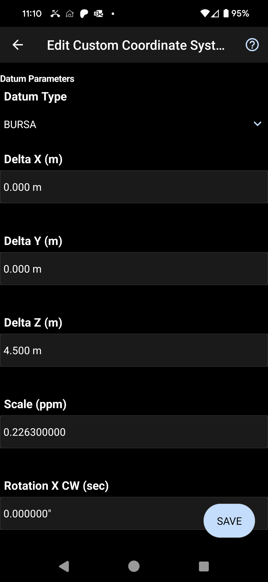
5. Datum Parameters: In most cases, the TOWGS84 section of the WKT listing contains only zeroes. In those cases there is no mathematical transformation to be applied in the coordinate system so you would select "None" under Datum type and continue to the Projection Type section of this article. Visit this webpage for specifics about the TOWGS84 definition. Please note that if your coordinate system requires that a grid shift file be applied that you will not be able to create the system. These types of systems can only be defined by our developers. Please create a support ticket and we can help you. Note that we would need documentation about the system and known test points. We won't use EPSG definitions alone to create a system.
|
Select the Datum Type "BURSA" Populate the 7 parameters from the TOWGS84 section by matching entries to the scheme below: TOWGS84[0,0,4.5,0,0,0.554,0.2263] TOWGS84[Deltax(m),Deltay(m),Deltaz(m),Rotation X CW (Sec) ,Rotation Y CW (Sec),Rotation Z CW (Sec) ,Scale (ppm)] |
 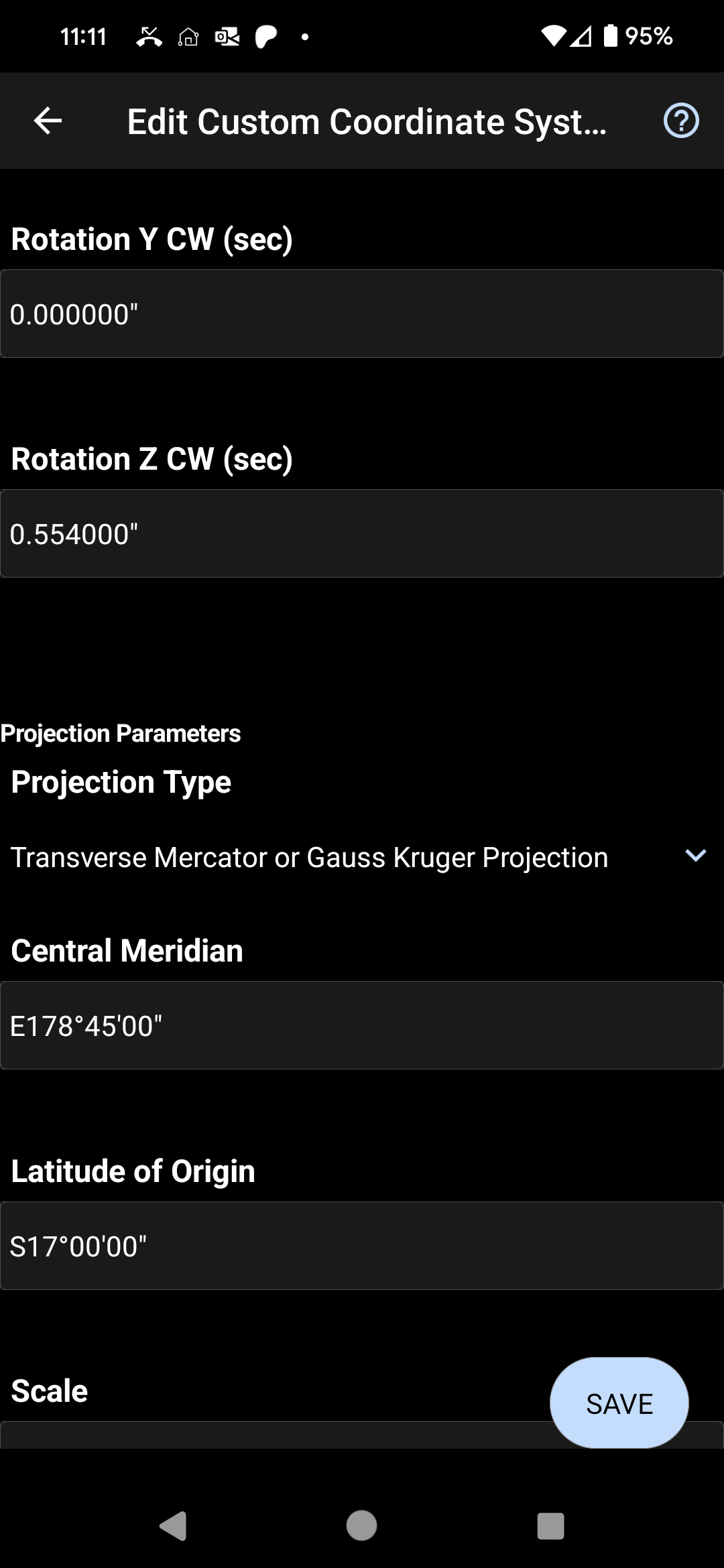 |
6. Define the Projection: Select a projection type from the menu and you will be prompted to define the parameters for this projection. In this article the parameters for a Transverse Mercator system are entered, but your parameters will likely be different.
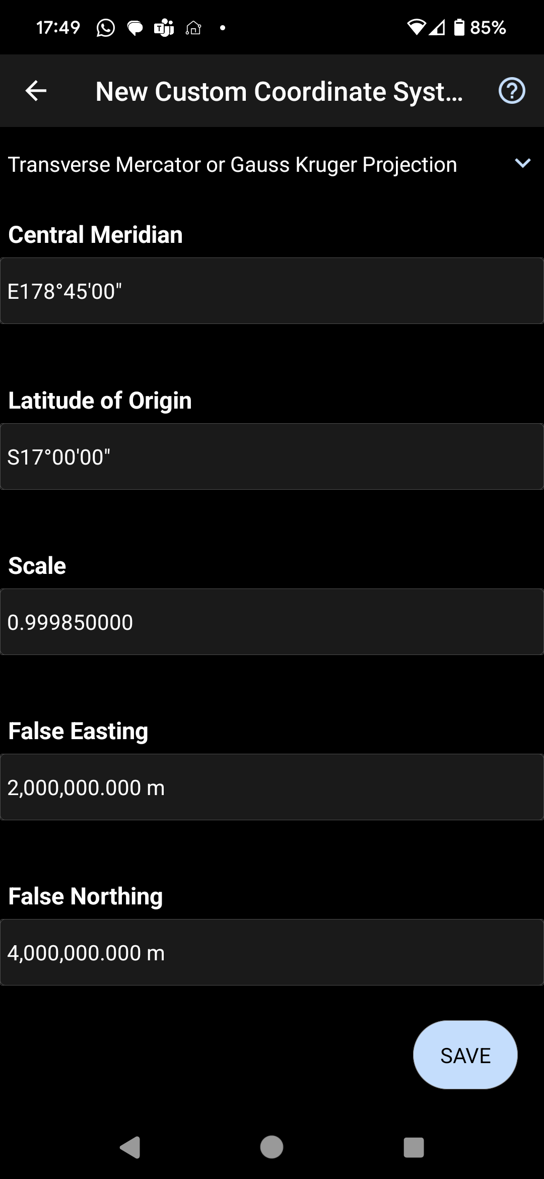
| Select the Transverse Mercator or Gauss Kruger Projection Type as defined in the PROJECTION listing: ["Transverse_Mercator"], Define the Latitude of Origin as defined in the "latitude_of_origin" listing: PARAMETER["latitude_of_origin",-17] NOTE: Enter Northern Hemisphere Latitudes as Positive, Southern Hemisphere as negative. The"N"or"S" will be displayed after the entry is made. Define the Central Meridian as defined in the "central_meridian" listing: PARAMETER["central_meridian",178.75], NOTE: Enter Western Hemisphere Longitudes as Negative Values, Eastern Hemisphere as Positive. The"W"or"E" will be displayed after the entry is made. NOTE: The WKT value will be decimal degrees. It must be converted to DMS format before entry in MicroSurvey products. Define the Scale as defined in the "scale_factor"listing: PARAMETER ["scale_factor",0.99985], Define the False Easting as defined in the "false_easting" listing: PARAMETER["false_easting",2000000], Define the False Northing as defined in the "false_easting" listing: PARAMETER["false_northing",4000000], |
 |
7. Save your definition, and test it using the Geodetic calculator to ensure it converts a WGS84 Latitude/Longitude/Height to a correct XYZ value. EPSG has a "Transform" option which allows you to perform the same computation for comparison. However, we recommend using an additional test example provided by the local geodetic authority before assigning this system for production work.
James Johnston
Comments