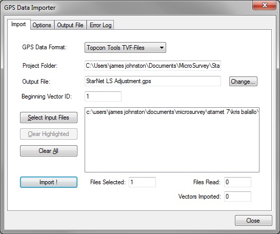
Topcon Tools has the ability to export gps vector data in a format which you can then import to STAR*NET from the Input menu:
Thanks to Martin Paquette at Renton Technical College for sharing this student guide with us. Please pick the link below for a pdf document:
Importing TVF data to Star*Net
NOTE:
Topcon users have reported that TVF vectors are not corrected for antenna height, so elevations can vary by the difference between the base height and rover height. Correct this by recording antenna heights in the field, and modifying each vector as shown in the example below:
#Original:
G0 'V2 VPP contra_loma_vector_file(all pts).tvf
G1 501-509 -37.779335 25.815941 2.625461 'SM9A
G2 4.898389636779E-04 7.113253746507E-04 6.189006858014E-04
G3 5.356000000000E-01 -5.119000000000E-01 -6.124000000000E-01
#Corrected:
G0 'V2 VPP contra_loma_vector_file(all pts).tvf
G1 501-509 -37.779335 25.815941 2.625461 AHbase/AHrover 'SM9A
G2 4.898389636779E-04 7.113253746507E-04 6.189006858014E-04
G3 5.356000000000E-01 -5.119000000000E-01 -6.124000000000E-01
NOTE:
An issue that may arise with older versions of Topcon Tools is that the vcf file may have a header at the top that is formatted incorrectly for STAR*NET. STAR*NET will search the header for an entry reporting the units of the vector file. It will look for:
METERS for meters
USFEET for U.S. Feet
IFEET for International Feet
The entries must be in capitals. If the header is not formatted as expected you will see an error message:
ERROR [ File: 34432-01.tvf | Line: 1 ]
It may be necessary to open the .tvf file in Notepad and edit it if you see a similar error.
Edit this entry:
//TopconVectorFormat:v.1,feet,
So it appears as below (if you wished to indicate International Feet):
//TopconVectorFormat:v.1,IFEET,
James Johnston
Comments