NOTE: This article applies to STAR*NET 7.2 or older. Newer versions of STAR*NET allow you to define custom coordinate systems withing the Project Options dialog.
Click here to watch a video on defining a custom coordinate system in STAR*NET 8.0 and newer.
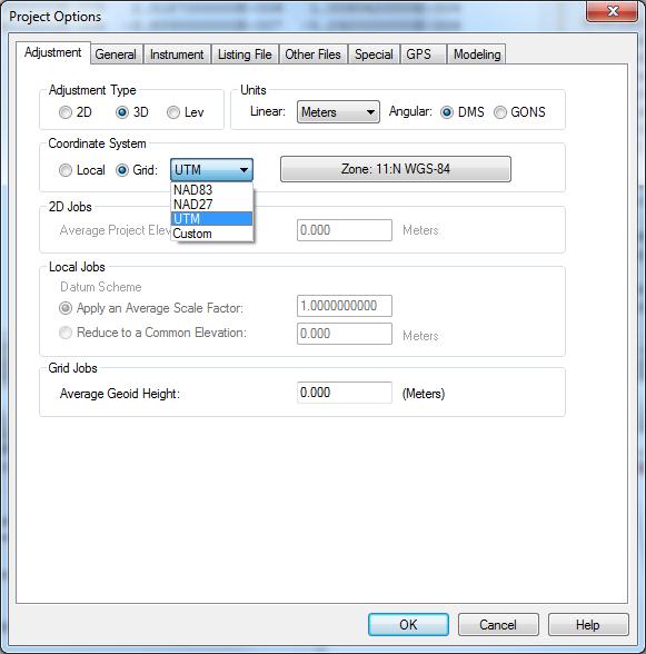
Star*Net includes a range of Pre-defined coordinate systems which users can select from project Options when creating their project:
But if the coordinate system you require does not appear in the predefined list you can add it to the StarNet.cus file.
This file can be edited using a text editor such as Windows Notepad.
You can find it in:
Windows XP: C:\Documents and Settings\All Users\Application Data\MicroSurveyMicroSurvey\StarNet\V7
Windows Vista/7: C:\ProgramData\MicroSurvey\StarNet\V7
When you open it you will find lots of comments explaining the formatting for various types of projections. We won't go into all the options in this article.
But here is an example of modifying the Starcus file so that MTM Coordinate systems ppear in the "Custom" group:
The red text was added to the Starcus file and then saved:
# Custom Projection Zones (All false northings and eastings are in meters!)
# =============================================================================
# T = Transverse Mercator
# L = Lambert Conic Conformal (One Standard Parallel)
# B = Lambert Conic Conformal (Two Standard Parallels)
# H = Hotine
# -----------------------------------------------------------------------------
# Note!!! When using "Custom" zones, be sure to use signs for your longitudes
# in this file and also in your data files. Longitudes are negative when entering
# angles measured west from Greenwich.
# -----------------------------------------------------------------------------
# T Zone Name: Ellipsoid Name: LatO CM FN FE Scale
# L Zone Name: Ellipsoid Name: LatO CM FN FE Scale
# B Zone Name: Ellipsoid Name: LatO CM FN FE LatS LatN
# H Zone Name: Ellipsoid Name: LatO LongO FN FE Scale TanSkewAz
# -----------------------------------------------------------------------------
T ON MTM 7: GRS-80: 0.0 -70.3 0 304800 .9999
T ON MTM 8: GRS-80: 0.0 -73.3 0 304800 .9999
T ON MTM 9: GRS-80: 0.0 -76.3 0 304800 .9999
T ON MTM 10: GRS-80: 0.0 -79.3 0 304800 .9999
T ON MTM 11: GRS-80: 0.0 -82.3 0 304800 .9999
T ON MTM 12: GRS-80: 0.0 -81.0 0 304800 .9999
T ON MTM 13: GRS-80: 0.0 -84.0 0 304800 .9999
T ON MTM 14: GRS-80: 0.0 -87.0 0 304800 .9999
T ON MTM 15: GRS-80: 0.0 -90.0 0 304800 .9999
T ON MTM 16: GRS-80: 0.0 -93.0 0 304800 .9999
T ON MTM 17: GRS-80: 0.0 -96.0 0 304800 .9999
Please note that these parameters were shared by a Star*Net user but MicroSurvey has not tested them so be sure to compare them with some published test points before using these in production work. Use at your own risk!
James Johnston
Comments