If you are a MSCAD user, visit the support area of the MicroSurvey website to acquire some of the free updates released in the past six months. Not only do the free updates to MSCAD 2002 make it possible to process data for FieldGenius XG 2.0, but there are several other improvements in the service patches.
1) Being able to extract LWPolylines as either data or breaklines for surface modelling. If you receive a drawing from another program that used LWPolylines to draw some 3D features, you can now use this data to help define a surface.
2) IPE – Independent Point Elevations (Similar to IPD and IPN)
3) IPEC - Independent Point Elevations Color – brings up a dialog that allows you to pick the color of the text for IPE (Similar to IPNC and IPDC)
4) SCALERAW - Some people find it hard to work with our RAW files when they need to be scaled to match UTM coordinates or convert from feet to meters, etc. They didn't like having to use the input toggle, so here is what we built.
In ADT, the function will apply a scale factor to all distances found in the RAW file.
This command will do the following:
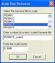
A) It will automatically prompt the user for a new traverse name. Once the user enters a traverse name, it will create a copy with this name.
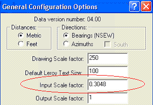
B) It will show, by default, a dialog with the scale factor set in the General Configurations Dialog. The user at this point will have the option of changing the scale factor.
C) When the user presses OK to the dialog in step 2, it will apply the scale factor to all the distances in the new/copied traverse file.
Before scaling:
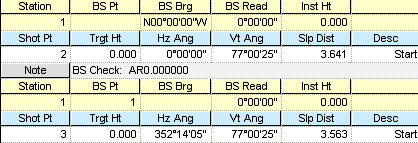
After Scaling:
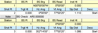
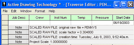
D) We will insert a note automatically into the new traverse file with the scale factor that was used, the name of the original RAW file, and the date and time that the file was created.
E) The user will not need to have the input scale factor on to do this.
F) The new traverse file will automatically be set as the current traverse file.
The beauty about this is you still have the original RAW file with original distances, it remains unchanged. You also don't have to worry about having the input toggle on so the RAW file is scaled.
5) IPSETTINGS – Controls all of the options for the IPE, IPN and IPD commands.
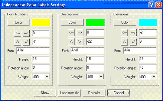
Allows you to change the Font and the way it appears on screen, for each.
6) WRITEXML – allows you to export all the points and any alignment info out to a Land XML file.
7) IPN, IPD, and IPE – these can now be viewed in any 3D view – previously only worked in plan view. The IP text is flat on the screen and not following the 3D plane.
8) In 3D view, you can now pick on any:
- Point number, Description, Elevation or Point Node and we will bring up the Coordinate Point Editor or ADT (depending upon how you are configured)
- Normal Text to bring up the text editor.
- Line or Arc to bring up CADLines or CADCurves
Previously these only worked in plan view.
Created on: July 25, 2003
Jason Poitras
Comments