MicroSurvey is pleased to announce the release of FieldGenius 8.0, a major update to its powerful and easy-to-use survey field data collection software.
Developed through close market collaboration and feedback from users, FieldGenius 8 provides tight control over crucial aspects of field data collection through expanded toolsets and an enhanced user experience.
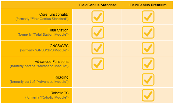
To provide more value to our customers, we have restructured the features in what used to be the "Advanced" module. Everthing except for the roading package and robotic functionality are now available for FREE to all FieldGenius users. (This includes surfaces, areas, volumes, slope staking, point scanning, and more.)
We have also simplified the product options for FieldGenius, offering the two most popular configurations as the "Standard" and "Premium" editions, respectively:
Check out the Release Note & Overview for complete list of features and bug fixes
New Features and Changes
-
Redesigned GNSS Local Transformation
- All new easy-to-use interface
- Ability to export/import localization files
- Added 7 parameter Helmert transformation
- Ability to delete or reuse control points
- Improved scaling and many other options
- See the new GNSS features in the movies page
-
DXF Enhancements
- DXF Blocks are now supported
- Extrusion vectors on various entities are now supported
- Improvements to circles and other entities types
- Layer visibility settings from CAD programs will now be honoured
- Added a dialog to list entities during import
-
Advanced Point Averaging Routine
- A new feature that allows user to take multiple temporary measurements of a point using either Total Stations or GNSS receivers, select the best ones, and calculate an averaged position for better accuracy and reliability.
-
Electronic Bubble Support
- Tilt compensation/Rejection is now available on supported GNSS receivers that enables tilted surveying at corners or edges of walls.
-
GIS Attributes for Figures
- GIS Attributes are now supported for figures
- Users can quickly select Default/Previous attribute values for both points and figures.
-
Roads Module Improvements
- Alignment toolbar added to enable easy navigation between alignments and Roads Manager
- Station/Offset/Cut/Fill are now visible in the observation toolbar and point database to display position relative to the selected alignments
- Added the ability to arrange alignment label intervals and orientations
-
Unicode Encoding Support
- Unicode is now supported throughout the program, which includes point descriptions, profiles, settings, exported files, and more.
-
ASCII Export Improvements
- Added the ability to sort points by either time or point ID
- Post-processing time markers can be exported in either GPS time or UTC time
- The encoding of the export file can be either ANSI or Unicode
- Added an option to export all measurements used for averaged points
- More options are available for custom ASCII export formats
- Basic Measure Mode – a new measure screen has been added for total Station onboard version that allows quick measurements without even creating a project.
- Total Station Target and Measurement Improvements – Target and EDM updates are now more consistent between FieldGenius and total stations. Each measurement is noticeably faster.
- Dynamic Screen Rotation – FieldGenius now dynamically rotations between landscape and portrait mode on Windows 8.1+ tablets.
- Total Station Angular Precision Control – Angular measurements from total stations can now be rounded to different level of precisions.
- More Serial Ports – Choosing <COMXX> option during connection setup will allow user-definable COM port from 1 to 99.
- Added an option that allows user to manually define point increment interval
- GNSS Auto Store mode prompts for interval selection automatically
- The decimal feet unit option has been replaced by feet and inches throughout the program
- Entering licensing key will be easier now with cursor auto-advancing
- Added CST ASCII output format for compatibility with Leica ECLIPSE Neo
- Special support has been added for Japanese JENOBA network
- Post-Processing Tagging option is now always enabled
- Observation toolbar state now persistent between sessions
- Stakeout viewing modes are now persistent between sessions
- Show ToolTips option is now persistent between sessions
- Standard deviation values have been added to the averaging screen in point database.
- Grid view has been enabled on the PC/Tablet version
- Improved resolution of some icons
- Headers for ASCII export is now defaulted to be OFF
- Improved screen focuses on various buttons during connection process
- Improved various error messages in the ASCII Import
Hardware Specific Updates
-
Altus
- APS-NR2 – Added support for APS-NR2 GNSS receivers
-
ComNav
- T300 – Correction messages will no longer be outputted when switching from Base to Rover mode
- T300 – Fixed an issue with Averaged Position in the base mode
-
FOIF
- A30 – Electronic Bubble/Tilt Sensor support has been added for this instrument
- A30 – Fixed a problem with GSM module when requesting source table
- A30 – Updated antenna calibration values and add hook offsets
- RTS-350 – Added an option to enable/disable laser dot in the instrument settings
-
GeoMax
- Zenith 04 – Added support for Zenith04 data collectors
- Zenith 10/20 – Fixed a cosmetic issue with satellite plot where satellites are incorrectly displayed as not part of the solution. (This fix also requires ME firmware v6.600 or newer)
- Zenith 25 – Fixed a compatibility issue with Quebec network RTK service
- All Total Stations – Improved target list in Target Manager
-
geo-FENNEL
- FGS 1 – Correction messages will no longer be outputted when switching from Base to Rover mode
- FGS 1 – Fixed an issue with Averaged Position in the base mode
-
Hi-Target
- V30 – Resolved a compatibility issue with CORS-TR network
-
Handheld
- Nautiz X8 – Splash screen now displays correctly
- Nautiz X8 – Fixed a memory issue involving the stakeout screen
- Algiz 10X – Added support for Algiz 10X tablets
-
Hemisphere
- S320 – Added support for S320 GNSS receivers
-
KOLIDA
- K96T – Driver updated as instructed by KOLIDA
-
KQ GEO
- M8 – Added support for M8 GNSS receivers
- K8 – Added support for K8 data collectors
-
Leica
- Viva TS16 – Added support for Viva TS16 total stations
- Nova TS60 – Added support for Nova TS60 total stations
- Nova MS60 – Added support for Nova MS16 multi stations
- CS20 – Added support for CS20 data collectors
- CS35 – Added support for CS35 data collectors
- GS14 – Resolved a GSM module compatibility issue with firmware 5.61
- 1100 TCRA – Significantly reduced measurement time and improved target management
- iCON robot 60 – Improved power search and tracking
- ZenoConnect – Added support for ZenoConnect series of GIS devices with improved antenna profiles
-
Linertec
- LGP-300 Series – Added an option to enable/disable laser dot in the instrument settings
- LGP-300 Series – Can now be connected through data collectors
-
NavCom
- SF-3040 – Added support for FEC control for SF-3040
- SF-3040 – Fixed an issue with auto-store function in time internal mode
-
Pentax
- W-1500 Series – Can now be connected to a data collector
- W-1500 Series – Added an option to enable/disable laser dot in the instrument settings
- W-1500 Series – Level of angular precision has been improved
- W-1500 Series – Added Battery indicator
- W-1500 Series – Fixed an issue where switching between No Prism modes will stop measurement updates
- W-1500 Series – Tilt correction check is now set to 3’20”
- W-1500 Series – Added a warning message for class 3R laser
- W-1500 Series – ESC button will cancel/stop loop measurement mode
- G3100-R2 – Antenna calibration values have been updated
- P7H – Added support for P7H data collectors
- All GNSS receivers – Antenna definitions have been updated (requires latest firmware)
-
Prexiso
- G4/G5 – Direct dial (CSD) option has been added
-
Spectra Precision
- SP80 – Added support for SP80 GNSS receivers
-
Stonex
- W-R2W Plus Series – Added an option to enable/disable laser dot in the instrument settings
-
South
- S650/S660 – Added support for S650/S660 GNSS receivers
- GALAXY G1 – Added support for GALAXY G1 GNSS receivers (Electronic Bubble supported)
- NTS-36R0 – Fixed an angular issue when using gradient unit on data collectors
-
Topcon
- Hiper – Fixed an issue where Arwest radio was not responding quickly enough to driver’s request
Download FieldGenius 8.0
For demonstration purposes, MicroSurvey FieldGenius can be run as a full featured demo limited to 30 points.
Download Additional Supporting Applications
MicroSurvey Transfer (free add-on for FieldGenius users, requires Microsoft ActiveSync or Windows Mobile Device Center): Click Here
Yifan Xia
Comments