MicroSurvey FieldGenius fully supports Leica's many receiver models from the GS14 upwards.
FieldGenius is primarily used in an RTK environment as it allows for simple topography work and combines easily with data collected by total stations and other manufacturers.
But if an RTK link is unavailable, FieldGenius can be used to trigger static logging on the Leica receiver:
If it is a base receiver, you can start static logging by accessing the Instrument settings icon from the mapview and selecting raw data logging once you are connected to the base. You will be prompted to select a folder to store the static data and a name to use for the static data. This data can later be imported into Leica Infinity and post processing performed.
If it is a rover receiver the procedure must be different in order to collect data that Infinity can process. Please visit this article for the exact procedure.
However if the field crew is unfamiliar with the correct procedure, it is possible to trigger static logging using an incorrect procedure and the static data will be collected but incorrectly formatted for use with Leica Infinity. A user has shared a procedure with us that allowed them to correct the data and not have to re-do the fieldwork:
- Once the static data is imported into Infinity, properly collected data will be labeled as "Static" and will result as a single point after post processing. If the data is improperly collected, it will be labelled as "moving" and will result in multiple points being computed during post processing.
- If you've identified that your static data is improperly collected, you can correct the problem following this procedure:
- Export the data as rinex from Infinity
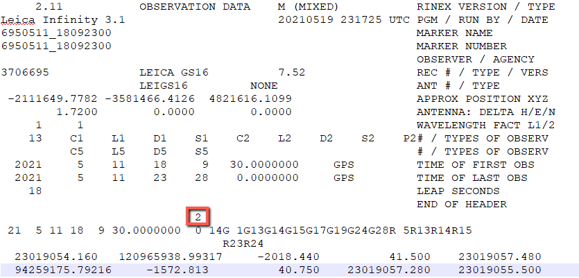
- open the rinex file in a text editor.
- If the data is identified as "moving" a "2" will appear as shown in red below
- Correct this by changing the entry to "1"
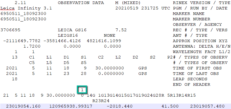
- Save the file
- Import it into Infinity and perform post processing
Thanks to Sim Porcatello at AllTerra Land Surveying for sharing this information with us.
James Johnston
Comments